Deep Sea Collaboration: ROV Hercules and AUV Sentry Team Up in American Samoa

The NA165 E Mamana Ou Gataifale II expedition sees a team-up of two amazing pieces of ocean exploration technology. The Corps of Exploration are using E/V Nautilus’ remotely operated vehicles Hercules and Atalanta and Woods Hole Oceanographic Institution’s autonomous underwater vehicle (AUV) (AUV) Sentry to expand the amount of exploration possible. AUV Sentry produces bathymetric, sidescan, subbottom, and magnetic maps of the seafloor and is capable of taking digital bottom photographs in a variety of deep-sea terrains such as mid-ocean ridges, deep-sea vents, and cold seeps at ocean margins. Together, these operations will provide important data for interpretations of seafloor biological density and diversity, enhancing mission planning and enhancing our opportunities to survey cultural heritage sites.
“Woods Hole Oceanographic Institution has partnered with OET, OECI, NOAA, and BOEM to advance deep-sea exploration using the cutting-edge AUV Sentry. AUV Sentry, a unique and highly capable autonomous vehicle, is designed to excel in challenging and unexplored environments, collecting crucial data such as multibeam sonar, magnetic readings, and chemical signatures that enhance our understanding of these remarkable deep-water ecosystems,” says Sean Kelley, AUV Sentry Program Manager at WHOI.

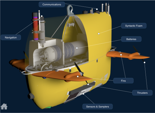
AUV Sentry was designed to conduct seafloor surveys at low altitudes and in rough or complex topography. The vehicle is owned by Woods Hole Oceanographic Institution, operated by the National Deep Submergence Facility, and funded by the National Science Foundation. AUV Sentry is rated to 6,000 meters (19,685 feet) and equipped with a high-resolution photo camera, an EM2040 multibeam sonar, sub-bottom profiler, and other sensors to study the deep seabed. Sentry can be used as a stand-alone vehicle or, as is the case with this expedition, alongside a remotely operated vehicle like ROV Hercules to scout regions ahead of dives by those vehicles to increase the efficiency of deep-submergence investigations.
During the expedition, AUV Sentry surveys will map benthic habitats targeting three main areas,
- benthic habitats 5,000-6,000 meters deep located towards the southeastern corner of the US Exclusive Economic Zone of American Samoa to support BOEM and USGS science priorities
- the water column above and seafloor habitats around Vailuluʻu Seamount to collect in situ environmental and backscatter data, enhancing future capabilities to using the AUV’s sensors and test an algorithm designed to trace hydrothermal plumes to its source
- the seabed northwest of Tutuila in search of the ongoing search for the Samoan Clipper underwater cultural heritage site in deep water off the northwest shore of Tutuila Island
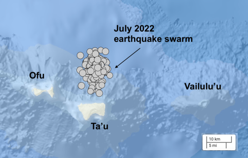
In addition to mapping the active submarine volcano Vailuluʻu with E/V Nautilus’ multibeam sonars, a 2019 OET expedition used the high-resolution video imagery collected via ROV to generate a three-dimensional model of the top of the seamount. This year, OET’s expeditions in American Samoa’s waters will use both Sentry and Hercules to search for changes to the region’s seamounts and seafloor. These will be the first surveys of an area north of Taʻū Island, which experienced a seismic crisis (swarm of seafloor earthquakes) in 2022.

During the NA164 expedition, three different robotic systems were used to gather information about Vailulu’u’s fascinating environment and its overlying waters. The NA165 expedition continues efforts from the 18-day E Mamana Ou Gataifale I expedition, which mapped within the National Marine Sanctuary of American Samoa and gathered data from the biodiverse mid-water ocean twilight zone using underwater vehicles launched from E/V Nautilus and from shore. Both expeditions will provide publicly accessible data for local resource managers and scientists worldwide.
Stay tuned as we spend three weeks in the waters in and around the National Marine Sanctuary of American Samoa, exploring the deep ocean with ROV Hercules and AUV Sentry!

E Mamana Ou Gataifale II - American Samoa
American Samoa is the southernmost U.S. territory, centered in the South Pacific, 2,300 miles southwest of Hawaiʻi, and 1,500 miles northeast of New Zealand. It is home to the cradle of Polynesia’s oldest culture.


