Exploring the National Marine Sanctuary of American Samoa
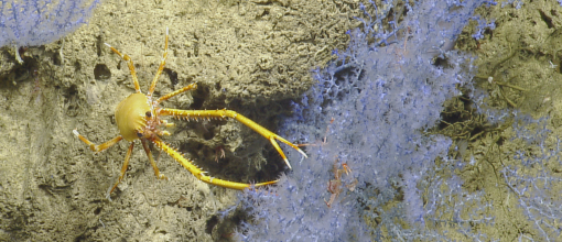
As Nautilus continues to explore the South Pacific, the team will acquire baseline information on deep sea and mesophotic habitat in American Samoa, with a special focus on the National Marine Sanctuary of American Samoa. Within deep sea habitats, seafloor geology and biological communities will be documented and sampled while searching for potentially new species of deep sea coral. The Nautilus expedition will also conduct deep water seafloor mapping, as well as shallow water seafloor mapping using an Autonomous Surface Vehicle (ASV). ROV dives to survey fish and benthic communities will be planned near all islands and seamounts within the American Samoa archipelago, including Tutuila, Ta’u, Ofu-Ologesa, Rose Atoll, Swains Island, Vailulu’u Seamount, and Malulu seamount.
The expedition from July 23-August 5, 2019 is led by the National Marine Sanctuary of American Samoa, with Lead Scientist Dr. Mareike Sudek on shore and Co-Lead Scientist Hanae Spathias aboard Nautilus, with Expedition Leader Dr. Christopher Roman, University of Rhode Island/Ocean Exploration Trust. Building upon data collected in 2017 by NOAA Ship Okeanos Explorer, this expedition marks the first partnership between the National Marine Sanctuary of American Samoa and the Ocean Exploration Trust, and is sponsored by NOAA Office of National Marine Sanctuaries. Other important partners are the National Park of American Samoa, the Coral Reef Advisory Group, and the Department of Marine and Wildlife Resources.
Sailing the Southernmost U.S. Territory
American Samoa is the southernmost U.S. Territory at 14.27 ºS, 170.13 ºW in the South Pacific. It is comprised of five volcanic high islands (Tutuila, Aunu’u, Ofu, Olosega, and Ta’u) and two atolls (Rose and Swains) with a total land area of about 200 km2.
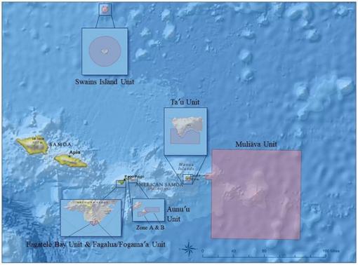
National Marine Sanctuary of American Samoa (NMSAS) is composed of six protected areas covering 13,581 square miles of nearshore coral reef and offshore ocean waters across the Samoan Archipelago. It was formerly known as Fagatele Bay National Marine Sanctuary (designated in 1986), which was established to protect 0.25 square miles of coral reef habitat in Fagatele Bay. In 2012, the sanctuary expanded to include Fagalua/Fogāma’a on Tutuila Island, as well as areas on Aunu’u, Ta’u, and Swains Islands, and Muliāva, a management area that overlays Rose Atoll Marine National Monument and includes nearby Vailulu’u and Malulu Seamounts.
American Samoa is an oceanic archipelago with a small insular shelf, with shallow water seafloor habitats within 0.5 to 2 miles from shore and then quickly dropping into a steep slope to mesophotic and deep sea depths. As such, pelagic or open ocean waters constitute the primary habitat within the archipelago, overlaying deep ocean floor and seamounts. Mesophotic coral ecosystems occur from 30m to over 150m and are one of the most understudied components of the coral reef ecosystem. A few existing studies in American Samoa have documented flourishing coral communities at mesophotic depths between 30-110m but the deep sea past 150m remains largely unexplored, and little is known about the species that thrive in these extreme conditions.
Vailulu’u Seamount is located in between the Manu’a islands and Rose Atoll and is the only hydrothermally active seamount within the American Samoa Exclusive Economic Zone. Discovered in 1975 and first mapped in 1999, Vailulu'u seamount has been mapped in high resolution by multibeam sonar and recent bathymetric data shows that the volcanic cone in the crater, called Nafanua, has grown substantially. Additionally, a mapping effort in 2017 aboard NOAA Ship Okeanos Explorer identified plumes, likely composed of CO2 gas, rising from the location of previously identified hydrothermal vents, and rapid community changes associated with active volcanism were observed as well. Malulu Seamount is located in between Vailulu’u seamount and Rose Atoll, and is very deep, lying from 2,400 meters to 4,800 meters in depth. Seamount M. or Northeast bank has a flat summit that lies within 100 m of the sea surface, and very little is known about the associated biological communities on either seamount.
The baseline data collected by previous research has provided a glimpse into the Mesophotic Coral Ecosystem (MCE) and deep sea habitats of the region, and data collection on the Nautilus expedition will help further characterize these habitats, as well as validate and further expand our knowledge of diversity and distribution of biological community assemblages within American Samoa and NMSAS.

Expedition Objectives
Biological census
Increase our understanding of the diversity and distribution of biota in the deep sea and mesophotic communities within American Samoa. 1) Identify and quantify benthic organisms, e.g. coral, gorgonians, algae and other benthic invertebrates, 2) Record fish diversity through video transects, 3) Employ innovative 3D reconstruction methods (structure from motion) with submersible vehicle to create high resolution 3D models and annotated mosaic imagery of the substrate. 3D mapping of the habitat will provide visual baselines of the habitats as well as means to precisely quantify the composition and habitat structure at each site.
Volcanic Terrain Assessment
Explore the volcanically active crater of Vailulu’u seamount and document changes since the Okeanos Explorer dive in 2017 to provide information about the successional changes in the biological communities associated with changes in the environmental setting as a result of active volcanism. Vailulu’u seamount will be revisited to 1) remap the crater and determine the growth of the Nafanua cone since 2017, and 2) conduct a ROV dive near the Nafanua cone to record changes in the biological communities and assess recent volcanic activity.
Seafloor mapping
The need for high-resolution bathymetry and backscatter maps for shallow water habitats (such as coral reefs, and MCEs) in American Samoa has been expressed by various local agencies. The goal is to map priority areas around the American Samoa archipelago as completely as possible using an ASV equipped with a Kongsberg EM2040p multi-beam echo-sounder (0-200m). Additionally, the hull-mounted Kongsberg EM302 multibeam sonar system will map deeper than 250m to supplement existing bathymetry maps and fill gaps.
Targeted sampling
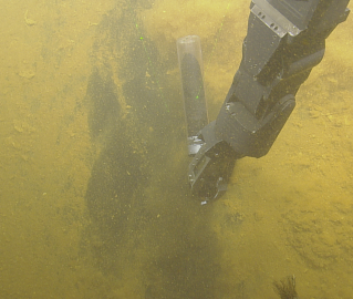
Environmental data (e.g. depth, temperature, salinity, dissolved oxygen) will be collected using the ROV. Samples of specimens of interest (i.e various invertebrates), as well as rock samples, will be collected using the manipulator arm of the ROV and then further processed on the ship. Water samples will be collected using the seabird CTD for stratified deep sea samples.
Engagement
The team aims to build local capacity in the form of student participation in the research cruise and also engage the general public via live telepresence of the ROV dives, cruise blogging, and live social media cruise postings. One student from the local American Samoa Community College will participate on the research cruise to gain experience in applied marine biology and get hands-on experience in STEM related activities.

National Marine Sanctuary of American Samoa
The main objective of this expedition is to acquire baseline information on deep-sea and mesophotic habitat in American Samoa, with a special focus on the National Marine Sanctuary of American Samoa (NMSAS). Within deep-sea habitats, seafloor geology and biological communities will be documented and potentially new species of deep-sea coral and subsamples of rocks will be collected.


